
Fil:Map of British plantations of Ireland, 1550–1610.png

Der findes ingen højere opløsning af billedet
Map_of_British_plantations_of_Ireland,_1550–1610.png (466 × 565 billedpunkter, filstørrelse: 7 KB, MIME-type: image/png)
|
|
Denne fil er fra Wikimedia Commons. Beskrivelsen af filen fra Commons er gengivet nedenfor. |
Beskrivelse
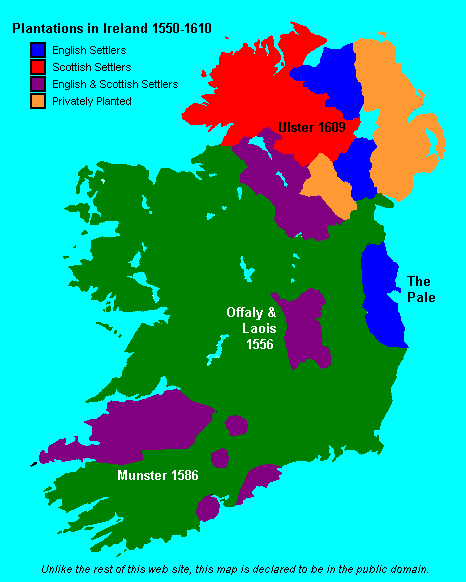
| Beskrivelse |
English: Map showing the major British crown-organised and private-sector "plantations" (colonies) in Ireland from ca. 1550 to 1610. Colour-coded as to Scottish, English or a mixture (other than it is not clear that the privately organized plantations in Ulster varied in composition, but heavy toward the Scots side). This file is supplied as requested PNG replacement for an undesirable GIF, though the entire thing would be better redone as an SVG. |
| Dato | (original 2007-05-09) |
| Kilde | Proximally, from GIF version; ultimately, from http://www.wesleyjohnston.com/users/ireland/maps/historical/map1609.gif |
| Forfatter | www.wesleyjohnston.com |
| Tilladelse (Genbrug af denne fil) |
Public domain by declaration of original creator (see notice at bottom of original GIF-format upload) |
| Andre versioner |
|

Licensering
License declared by original uploader User:NielsF:
| Jeg, indehaveren af ophavsretten til dette værk, udgiver dette værk som offentlig ejendom. Dette gælder i hele verden. I nogle lande er dette ikke juridisk muligt. I så fald: Jeg giver enhver ret til at anvende dette værk til ethvert formål, uden nogen restriktioner, medmindre sådanne restriktioner er påkrævede ved lov. |
Filhistorik
Klik på en dato/tid for at se filen som den så ud på det tidspunkt.
| Dato/tid | Miniaturebillede | Dimensioner | Bruger | Kommentar | |
|---|---|---|---|---|---|
| nuværende | 8. jun. 2024, 19:04 | | 466 × 565 (7 KB) | SMcCandlish | {{Information |Description={{en|Map showing the major British crown-organised and private-sector "plantations" (colonies) in Ireland from ca. 1550 to 1610. Colour-coded as to Scottish, English or a mixture (other than it is not clear that the privately organized plantation varied in composition; the one in Ulster predominantly Scots settlers, the more southerly ones predominantly English). This file is supplied as requested PNG replacement for an undesirable GIF, though the entire thing would... |
Filanvendelse
Den følgende side bruger denne fil:
Global filanvendelse
Følgende andre wikier anvender denne fil:
- Anvendelser på ar.wikipedia.org
- Anvendelser på de.wikipedia.org
- Anvendelser på en.wikipedia.org
- Anvendelser på nl.wikipedia.org
- Anvendelser på ru.wikipedia.org
- Anvendelser på simple.wikipedia.org