
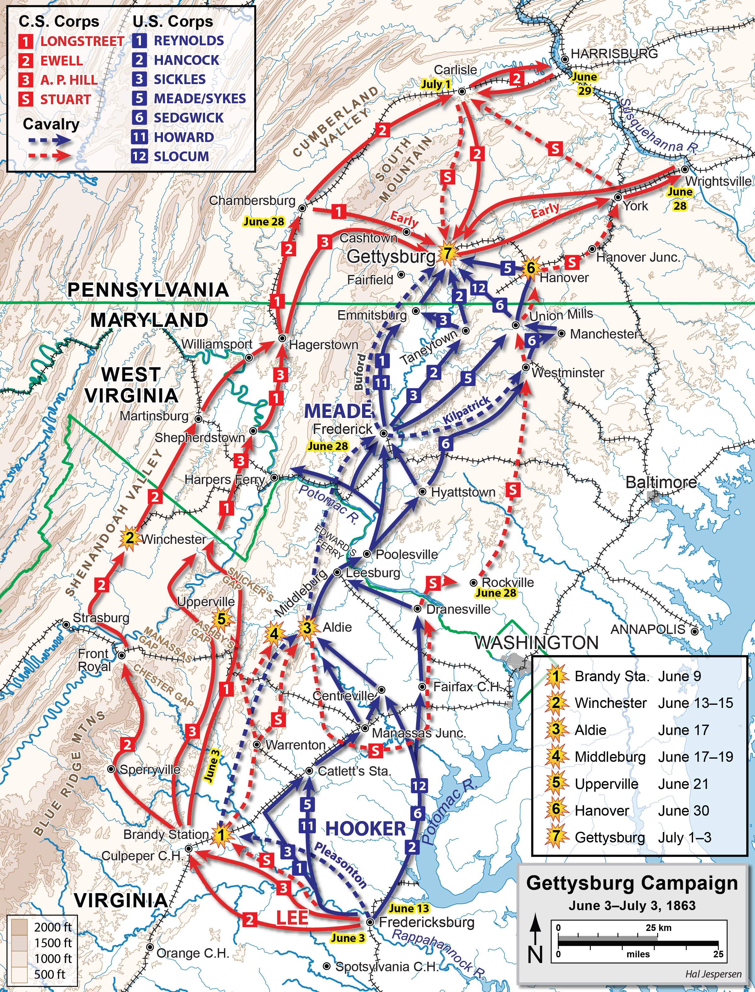
Fil:Gettysburg Campaign.png
Størrelse af denne forhåndsvisning: 457 × 600 pixels. Andre opløsninger: 183 × 240 pixels | 366 × 480 pixels | 585 × 768 pixels | 780 × 1.024 pixels | 2.400 × 3.150 pixels.
Fuld opløsning (2.400 × 3.150 billedpunkter, filstørrelse: 3,93 MB, MIME-type: image/png)
Commons er en samling af frie medier og du kan også hjælpe. |
Filhistorik
Klik på en dato/tid for at se filen som den så ud på det tidspunkt.
| Dato/tid | Miniaturebillede | Dimensioner | Bruger | Kommentar | |
|---|---|---|---|---|---|
| nuværende | 12. feb. 2021, 23:34 | | 2.400 × 3.150 (3,93 MB) | Hlj | Improved accuracy of my previous map version. |
| 29. nov. 2011, 21:26 |  | 1.652 × 2.360 (866 KB) | Hlj | Added the railroad between Baltimore and Westminster. same license. | |
| 2. apr. 2011, 20:53 |  | 1.652 × 2.360 (859 KB) | Hlj | Updated graphical format of rivers and roads. Same license. | |
| 20. jul. 2010, 16:13 |  | 1.652 × 2.360 (692 KB) | Hlj | Adjust graphics for more recent ACW map styling, add legend and scale. {{cc-by-3.0|Map by Hal Jespersen, www.posix.com/CW}} | |
| 16. aug. 2007, 01:25 |  | 1.636 × 2.374 (596 KB) | Hlj | {{Information |Description=Map of the Gettysburg Campaign of the American Civil War. Converted previous version to Adobe Illustrator. Graphic source file is available at http://www.posix.com/CWmaps/ |Source=own work |Date= August 15, 2007 |Author= Hal Jes | |
| 25. apr. 2007, 00:04 |  | 772 × 1.131 (361 KB) | Hlj | {{Information |Description= map of the Gettysburg Campaign of the American Civil War |Source=self-made |Date=April 24, 2007 |Author= User:Hlj }} | |
| 10. dec. 2006, 02:01 |  | 1.564 × 2.269 (164 KB) | BenFrantzDale~commonswiki | Same as previous version but with nicer colors. {{PD}} | |
| 9. okt. 2006, 01:00 |  | 1.564 × 2.269 (815 KB) | LERK | {{User:LERK/Information-other-user-image| language-code=en| language-name=English| wikimedia-project=Wikipedia| wikimedia-project-code=| des={{en|Map of the en:Gettysburg Campaign (up to July 3, 1863) of the en:American Civil War. Drawn by Hal |
Filanvendelse
Den følgende side bruger denne fil:
Global filanvendelse
Følgende andre wikier anvender denne fil:
- Anvendelser på br.wikipedia.org
- Anvendelser på ca.wikipedia.org
- Anvendelser på en.wikipedia.org
- Battle of Gettysburg
- J. E. B. Stuart
- History of Pennsylvania
- Gettysburg campaign
- Eastern theater of the American Civil War
- Portal:Pennsylvania
- List of Pennsylvania state historical markers in Adams County
- List of Pennsylvania state historical markers in Franklin County
- File talk:Gettysburg Campaign.png
- Anvendelser på es.wikipedia.org
- Anvendelser på fa.wikipedia.org
- Anvendelser på fr.wikipedia.org
- Anvendelser på hu.wikipedia.org
- Anvendelser på hy.wikipedia.org
- Anvendelser på it.wikipedia.org
- Anvendelser på ja.wikipedia.org
- Anvendelser på ko.wikipedia.org
- Anvendelser på pl.wikipedia.org
- Anvendelser på pt.wikipedia.org
- Anvendelser på ro.wikipedia.org
- Anvendelser på ru.wikipedia.org
- Anvendelser på sr.wikipedia.org
- Anvendelser på uk.wikipedia.org
- Anvendelser på vi.wikipedia.org