Spring til indhold

Fil:Florida STS51C-44-26.jpg

Sidens indhold er ikke tilgængeligt på andre sprog.
Fra Wikipedia, den frie encyklopædi

Fuld opløsning (4.095 × 4.095 billedpunkter, filstørrelse: 3,34 MB, MIME-type: image/jpeg)


Denne fil er fra Wikimedia Commons

Beskrivelse

Beskrivelse
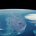
English: Florida Peninsula, January 1985
English: The Gulf of Mexico and the Gulf Stream bracket the Florida Peninsula on the west and east. The lighter shade of blue in the Gulf of Mexico is due to the much shallower (continental shelf) water depths of less than 200 feet (60 meters), whereas the much darker blue of the Gulf Stream is due to water depths in excess of 2000 feet (610 meters). Tampa Bay and Charlotte Harbor are fairly large water embayments along the west coast, and Lake Okeechobee is the large body of water in the south-central part of the state. Numerous smaller lakes can also be seen generally extending north and south through the central part of the state. Practically all of the lakes in central Florida have been created by the interaction of water with the limestone rock that underlies most of the state. Thus, through time, sinkholes have developed, occasionally swallowing houses and roads as the limestone rock collapses. This type of topography is termed "karst." Visible along the southeastern coast of Florida is a large urban area that stretches roughly from Homestead in the south to beyond West Palm Beach in the north (including the greater Miami area). This built-up area is known as the "Gold Coast" of Florida. To the west of this vibrant and ever-growing urban area is the vast, relatively uniform-looking swampland of the Everglades, which is virtually uninhabited by humans. In fact, most of the flat, saw grass landscape is occasionally interrupted by small stands of hardwood hammocks; this area is part of the Big Cypress National Preserve and the Everglades National Park. Most of the Florida Keys are visible as they form an archipelago that arcs to the southwest from the southern tip of Florida. Also visible are parallel lines of clouds that have been formed as a cool air mass from the northwest is pushed across the warmer water of the Gulf Stream. A very faint smoke plume that originates near the Georgia-South Carolina border provides a clue to the wind direction at the time this photograph was taken.
Dato
Kilde NASA Image and Video Library JSC Gateway to Astronaut Photography of Earth
Forfatter NASA
Camera
InfoField
Hasselblad
Focal length
InfoField
100 mm
Film
InfoField
5017: Kodak, natural color positive, Ektachrome, X Professional, ASA 64, standard base
Content Provider
InfoField
Kamlesh P. Lulla Ph.D. Chief, Earth Sciences Branch
Responsible NASA Official
InfoField
Ed Wilson
Curator
InfoField
Jaime Powell
Kameraposition20° 54′ 00″ N, 79° 30′ 00″ W Kartographer map based on OpenStreetMap.Dette og andre billeder på deres position på: OpenStreetMapinfo
Objektposition27° 00′ 00″ N, 81° 00′ 00″ W Kartographer map based on OpenStreetMap.Dette og andre billeder på deres position på: OpenStreetMapinfo
Dette billede eller video er katalogiseret af Johnson Space Center under National Aeronautics and Space Administration (NASA) ved foto ID: STS51C-44-26 og alternativt ID: 51C-44-026.

Denne tag indeholder og/eller påviser ingen ophavsretslige informationer eller kildeinformationer af dette medie. Rettigheder skal stadigvæk oplyses. Se Commons:Licensing for flere informationer.
Andre sprog:

Licensering

Public domain Denne fil er i offentligt domæne i USA fordi den udelukkende er skabt af NASA. NASAs ophavsretspolitik erklærer at materiale udgivet af NASA ikke er omfattet af ophavsret medmindre andet er nævnt. (Se også Template:PD-USGov, NASAs ophavsretspolitik eller JPLs politik for brug af billeder.)
Advarsler:

Captions

Tilføj en kort forklaring på en enkelt linje om hvad filen viser
Florida Peninsula, January 1985

20°54'N, 79°30'W

100 millimeter

27°N, 81°W

Filhistorik

Klik på en dato/tid for at se filen som den så ud på det tidspunkt.

Dato/tidMiniaturebilledeDimensionerBrugerKommentar
nuværende14. feb. 2021, 14:24Miniature af versionen fra 14. feb. 2021, 14:244.095 × 4.095 (3,34 MB)AskeuhdHigher resolution version
1. sep. 2005, 10:25Miniature af versionen fra 1. sep. 2005, 10:25640 × 608 (80 KB)Roger469 == Fonte == Earth.Jonhson Space Center.National Aeronautic and Space Administration.government/Space Shuttle Earth Observations Photography/Earth From Space/low resolution.[ http://earth.jsc.nasa.gov/sseop/efs/lores.pl?PHOTO= STS51C-44-26 Florida – Cal

Den følgende side bruger denne fil:

Global filanvendelse

Følgende andre wikier anvender denne fil: