Spring til indhold

Fil:Europe map 1919.jpg

Sidens indhold er ikke tilgængeligt på andre sprog.
Fra Wikipedia, den frie encyklopædi

Fuld opløsning (1.920 × 1.440 billedpunkter, filstørrelse: 1,41 MB, MIME-type: image/jpeg)


Denne fil er fra Wikimedia Commons

Beskrivelse

Beskrivelse
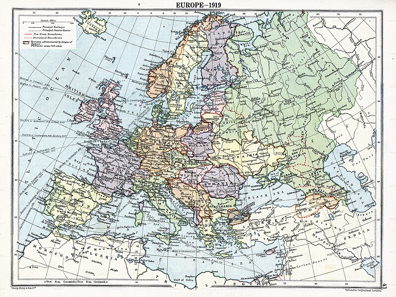
English: Map of en:Europe political divisions in 1919 (after the treaties of Brest-Litovsk and Versailles and before the treaties of Trianon, Riga, Kars and the establishment of en:Soviet Union and the republics of Ireland and Turkey) published by London Geographical Institute. This uploaded map is a photoshopped version of the original image located at hipkiss.org. According to the site, there are no copyrights to this map.
Kilde
Forfatter
Andre versioner Derivative works of this file:  Europe map 1919 cropped.JPG
Maps of the history of Europe
BCE
aC

Weichselian ice age (c. 113,000–9700) · Neolithic expansion (c. 7000–4500) · Middle Neolithic (c. 4500–4000) · Late Neolithic (c. 4000–3000) · Copper Age – Corded Ware culture (c. 2900–2350) · Copper Age – Bellbeaker culture (c. 2800–1800) · Early Bronze Age – Unetice culture (c. 2300–1600) · Late Bronze Age – Urnfield culture (c. 1300—750) · Migrations (c. 1000–100) · Hallstatt & La Tène cultures (c. 800–100) · Roman Republic (510–40) · 220 · 218 · 200 · 201–100 · 58 · 49 · 39 · 30 BCE–6 CE


CE
dC

14 · 14–37 · 60 · 60 · 69 · 80 · Migrations 100–500 · 117 · 117 · 125 · Migrations 150–774 · Economy 180 · 271 · 293–305 · 337 · 395 · c. 395 · 400 · 400 · 450 · 457–61 · 476 · 480 · Franks 481–814 · Early Slavs 500–700 · 500 · 526 · 526–600 · Christianisation to 600 · c. 550 · 650 · Pontic Steppe 650 · 665 · 800 · Vikings 800–1050 · 814 · 843–70 · 850 · 900 · 912 · 998 · 1000 · 1000 · 1054 · 1092 · First Crusade 1095–99 · 1097 · 1135 · 1142 · 1147–49 · 1190 · 1190 · 1250 · c. 1250 · 1301-1400 · 1301-1400 · 1328 · 1345 · Black Plague 1347–51 · 1360 · 1400 · Trade routes c. 1400 · 1430 · 1470 · 1490 · 1492 · 1500 · 1519 · 1550 · 1560 · Religion 1560 · Religion 1600 · Religion 1618 · 1618–48 · 1648 · 1683 · 1700 · 1701 · 1708 · 1714 · 1721 · 1725–30 · 1739–1740 · 1740 · 1748–66 · 1783–1792 · 1787 · 1787 · 1789 · 1799 · 1812 · 1812 · 1812 · 1812 · 1813 · 1815 · 1815 · 1815 · 1818 · Ottoman Empire 1830–1923 · 1848–49 · 1861 · 1867 · 1871 · 1878 · 1890 · 1905 · 1911 · 1914 · 1914 · 1919 · 1919–29 · 1923 · 1929 · 1930 · 1940 · 1941–42 · 1942–45 · Cold War 1947–91 · 1950 · 1993–2006 · 2006 to date

(this template: · view · discuss )

Licensering

Public domain
Public domain
Denne mediefil er offentlig ejendom i USA. Dette gælder for amerikanske værker, hvor ophavsretten er udløbet, ofte fordi dets første offentliggørelse fandt sted inden 1. januar 1929. Se denne side (på engelsk) for yderligere forklaring.

United States
United States
Dette billede er formentlig ikke offentlig ejendom uden for USA; dette gælder i sær i lande og områder, der ikke anvender rule of the shorter term for amerikanske værker, såsom Canada, Folkerepublikken Kina (ikke Hong Kong eller Macao), Tyskland, Mexico, and Schweiz. Skaberen og udgivelsesåret er afgørende oplysninger og skal fremlægges. Se Wikipedia:Offentlig ejendom og Wikipedia:Ophavsret for flere detaljer.

Oprindelig oplægningslog

The original description page was here. All following user names refer to en.wikipedia.
  • 2007-11-03 20:09 MaGioZal 1996×1506×8 (1457003 bytes) Map of [[Europe]] political divisions in 1919 (after the treaties of [[Treaty_of_Brest-Litovsk|Brest-Livotsk]] and [[Treaty of Versailles|Versailles]] and before the [[Treaty of Riga]] and the creation of [[Soviet Union]]) published by London Geographical

Captions

Tilføj en kort forklaring på en enkelt linje om hvad filen viser
The situation in Europe after WW1. Several new states were born such as Ukraine(the country in Yellow at the North of the Black Sea)

Elementer som er med i denne fil

afbilder

image/jpeg

Filhistorik

Klik på en dato/tid for at se filen som den så ud på det tidspunkt.

Dato/tidMiniaturebilledeDimensionerBrugerKommentar
nuværende7. aug. 2023, 06:41Miniature af versionen fra 7. aug. 2023, 06:411.920 × 1.440 (1,41 MB)User-duckCropped to reduce border using CropTool with lossless mode.
23. apr. 2008, 00:29Miniature af versionen fra 23. apr. 2008, 00:291.996 × 1.506 (1,39 MB)File Upload Bot (Magnus Manske) {{BotMoveToCommons|en.wikipedia}} {{Information |Description={{en|Map of en:Europe political divisions in 1919 (after the treaties of Brest-Livotsk and Versailles and before the treaties o

Den følgende side bruger denne fil:

Global filanvendelse

Følgende andre wikier anvender denne fil:

Vis flere globale anvendelser af denne fil.