
Fil:Administrative map of Romania, 1952-1956.png

Størrelse af denne forhåndsvisning: 800 × 572 pixels. Andre opløsninger: 320 × 229 pixels | 640 × 458 pixels | 1.024 × 732 pixels | 1.400 × 1.001 pixels.
Fuld opløsning (1.400 × 1.001 billedpunkter, filstørrelse: 338 KB, MIME-type: image/png)
|
|
Denne fil er fra Wikimedia Commons. Beskrivelsen af filen fra Commons er gengivet nedenfor. |
| Beskrivelse |
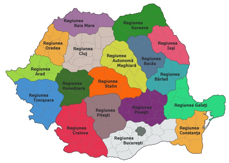
Administrative map of Romania, 1952-1956
|
| Kilde |
The original description page was here. All following user names refer to ro.wikipedia. |
| Forfatter | ro:user:Radufan |
| Dette værk er blevet udgivet som offentlig ejendom af dets skaber, Radufan. Dette gælder i hele verden. I nogle lande er dette ikke juridisk muligt. I så fald: |
Oprindelig oplægningslog
The original description page was here. All following user names refer to ro.wikipedia.
| Upload date | User | Bytes | Dimensions | Comment |
|---|---|---|---|---|
| 2006-10-02 00:26:09 | Radufan | 346530 | 1400×1001 | Impartirea Administrativ-teritoriala a Romaniei la 1953 |
Filhistorik
Klik på en dato/tid for at se filen som den så ud på det tidspunkt.
| Dato/tid | Miniaturebillede | Dimensioner | Bruger | Kommentar | |
|---|---|---|---|---|---|
| nuværende | 6. feb. 2010, 14:29 | | 1.400 × 1.001 (338 KB) | Alex:D | {{Information |Description=Administrative map of Romania, 1952-1956 *Bucharest had a special status of "town subordinated to the Republic" *Each region bears the name of the capital city, except: **Autonomous Hungarian Region — Târgu Mureş **Hunedoara |
Filanvendelse
Den følgende side bruger denne fil:
Global filanvendelse
Følgende andre wikier anvender denne fil:
- Anvendelser på en.wikipedia.org
- Anvendelser på es.wikipedia.org
- Anvendelser på fr.wikipedia.org
- Anvendelser på hu.wikipedia.org
- Anvendelser på it.wikipedia.org
- Anvendelser på nl.wikipedia.org
- Anvendelser på ro.wikipedia.org
- Județul Teleorman
- Regiunea Autonomă Maghiară
- Utilizator:Radufan
- Regiunea Timișoara
- Republica Populară Română
- Format:RegiuniRPR
- Regiunea Arad
- Regiunea Cluj
- Regiunea Stalin
- Regiunea Hunedoara
- Organizarea teritorială a Republicii Populare Române
- Regiunea Craiova
- Regiunea Ploiești
- Regiunea Pitești
- Regiunea Oradea
- Regiunea Baia Mare
- Regiunea București
- Regiunea Constanța
- Regiunea Galați
- Regiunea Bacău
- Regiunea Iași
- Regiunea Suceava
- Regiunea Bihor
- Regiunea Bârlad
- Diviziunile administrative istorice ale României
- Anvendelser på ru.wikipedia.org